Skip to content
GRENDELMAN.NET
  • Home
  • Photos
  • Projects & Pages
    • Projects
    • Files
    • Humor
    • Bookmarks
  • Login

Introducing “Taggert”, a GTK+3 geotagging application

Posted on: Monday 15 October 2012 /
Categories: GPS and mapping, Nerd Stuff, Photography

Up to now, I have been geotagging my pictures with gpsPhoto.pl, a command-line tool, that matches coordinates from GPX files with the timestamps on images. This works nicely, but it requires that you indeed have a GPX track from the time the picture was taken. For some time, I have been looking for a tool that allows me to do manual geotagging using a map.

I have found several tools that offer this functionality, or part of it. As a matter of fact, there are quite a few tools available for Windows, but I need one that runs on Linux, so I will not discuss those here. First, I found Geotag, a Java application, but it does not offer a map, so it isn’t very convenient. What I was looking for should look a lot like locr GPS Photo for Windows. This is, as the name suggests, a Windows-only tool.

Finally, I found GottenGeography, a GTK+ tool, written in Python, that does almost everything I want. Almost.

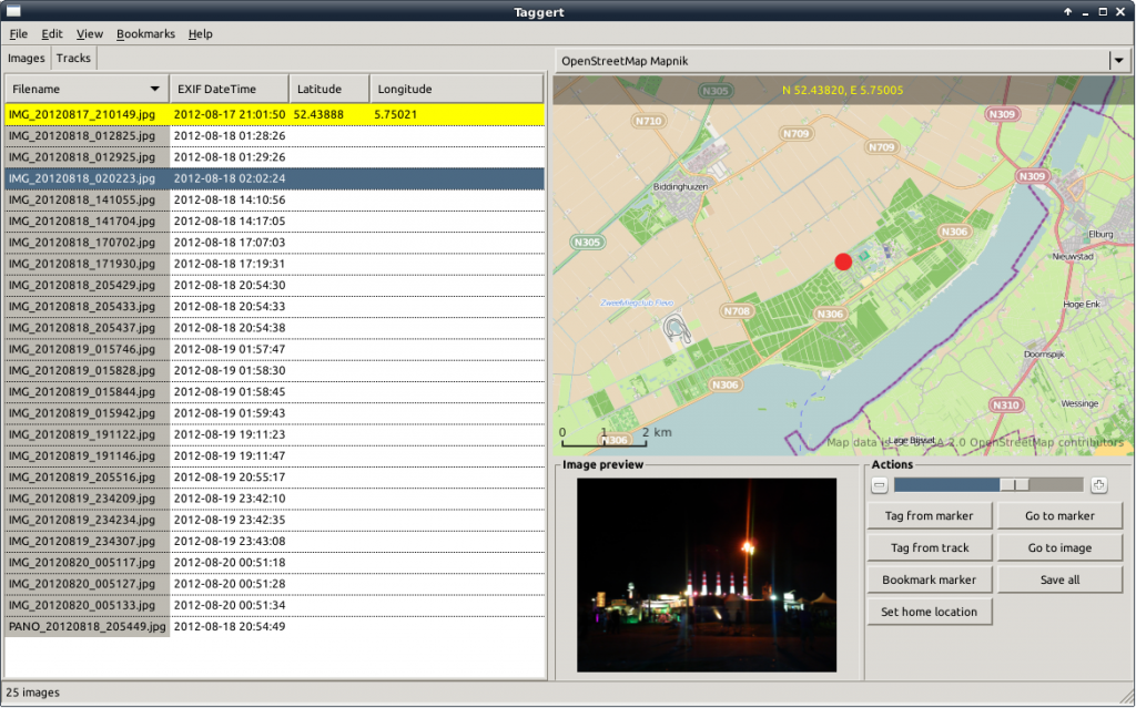
When I found GottenGeography, I had already started to explore the possibilities of writing a tool of my own, and the basis for Taggert was already there. After playing around with GottenGeography for a while, I decided I don’t like some of its design choices, and because creating a GTK+ application in Python seemed like a nice challenge, I decided to continue. And here it is: Taggert v1.0.

The README on Github explains what Taggert is, what it aims to be and how to try it out.

In short: Taggert allows add, change and remove geotags on your pictures, either manually using a marker on a map, or automatically using one of more GPX files containing GPS tracks. It allows you to store bookmarks for frequently-used locations and it supports multiple map sources, like OpenStreetMap and MapQuest.

In the near future, I hope to provide packages for different Linux distributions (at least Debian and Ubuntu). For now, you can download it from Github.
Tags: geotagging, GPS, gpx, taggert

Koffie-ijs zonder ijsmachine

Posted on: Sunday 16 September 2012 /
Categories: Uncategorized

Aangepast en vertaald in het Nederlands op 6 oktober.

Dit recept komt oorspronkelijk van http://www.eating-for-england.com/no-churn-coffee-ice-cream/, maar omdat ik die link al een paar keer kwijt was, en er bovendien Engelse maten in worden gebruikt, heb ik het recept hier overgenomen en aangepast aan het metrisch stelsel.

Homemade ice cream without a machine? I was gob smacked when I realised how easy this is. Learning to bake and cook over the last few years has included a series of fun surprises: I never would have guessed that any old person could make ice cream at home so dang easily.

I started my ice cream adventure with one of my all-time favourite flavours, coffee. Everything about this is reminiscent of Vietnamese coffee for me – the intense sweetness from both the heavy cream and sweetened condensed milk immediately transported me back to backpacking in South-East Asia, enjoying iced coffee on hot, steamy mornings. Not a bad thing to reminisce about on these humid, 100F Minnesota days with a cold cup of ice cream in hand.

Koffie-ijs zonder ijsmachine

adapted from Vanilla Bean

Ingrediënten

  • 1 blikje (*) gecondenseerde volle melk met suiker (Friesche Vlag)
  • 1/2 eetlepel vanilla-extract of aroma
  • 1/2 kopje (60 ml) sterke koffie, oftewel 1 flinke espresso, gekoeld
  • 250 ml slagroom, gekoeld

(*) Een blikje gecondenseerde melk van Friesche Vlag bevat iets meer inhoud dan nodig

Instructies

  • Doe de room en de koffie in een kom en klop het mengsel stijf met een mixer
  • In een andere kom, meet 220 ml gecondenseerde melk af en voeg het vanille-extract toe
  • Schep met een rubber spatel de geslagen room bij de gecondenseerde melk en schep voorzichtig om, totdat het een homogeen mengsel is
  • Zet het mengsel in de vriezer en laat tenminste 6 uur invriezen

The Dirty Denims op Lowlands

Posted on: Thursday 23 August 2012 /
Categories: Photography

18 augustus 2012

IMG_5240.JPG

2012-08-18 13:57:52
© 2012 Martijn Grendelman
IMG_5241.JPG

2012-08-18 14:01:53
© 2012 Martijn Grendelman
IMG_5242.JPG

2012-08-18 14:02:01
© 2012 Martijn Grendelman
IMG_5243.JPG

2012-08-18 14:02:12
© 2012 Martijn Grendelman
IMG_5244.JPG

2012-08-18 14:02:24
© 2012 Martijn Grendelman
IMG_5245.JPG

2012-08-18 14:02:31
© 2012 Martijn Grendelman
IMG_5246.JPG

2012-08-18 14:02:39
© 2012 Martijn Grendelman
IMG_5247.JPG

2012-08-18 14:04:20
© 2012 Martijn Grendelman
IMG_5248.JPG

2012-08-18 14:07:04
© 2012 Martijn Grendelman
IMG_5249.JPG

2012-08-18 14:07:16
© 2012 Martijn Grendelman
IMG_5250.JPG

2012-08-18 14:07:25
© 2012 Martijn Grendelman
IMG_5251-1000.mp4.jpg

2012-08-23 08:30:49
© 2012 Martijn Grendelman
IMG_5252.JPG

2012-08-18 14:23:55
© 2012 Martijn Grendelman
IMG_5253.JPG

2012-08-18 14:24:09
© 2012 Martijn Grendelman
IMG_5254.JPG

2012-08-18 14:24:19
© 2012 Martijn Grendelman
IMG_5255.JPG

2012-08-18 14:26:06
© 2012 Martijn Grendelman
IMG_5256.JPG

2012-08-18 14:33:25
© 2012 Martijn Grendelman
IMG_5257.JPG

2012-08-18 14:36:32
© 2012 Martijn Grendelman
IMG_5258.JPG

2012-08-18 14:36:55
© 2012 Martijn Grendelman

Om 14:00u in de Charlie.

Tags: dirty denims, lowlands

Alpha by sunset

Posted on: Wednesday 22 August 2012 /
Categories: Photography
IMG_5277
Tags: lowlands

Octocopter bij Lowlands-camping

Posted on: Wednesday 22 August 2012 /
Categories: Nerd Stuff, Photography

Afgelopen zaterdag zagen we op Lowlands camping 1 ineens een UFO boven de camping vliegen. Nader onderzoek wees uit, dat het om een octocopter ging:

IMG_5237
IMG_5238

Op de octocopter staat de URL tfcm.nl, wat blijkt te staan voor The Flying Camera Men. Ik heb ze een mail gestuurd met de vraag of de beelden die ze op Lowlands hebben geschoten ergens te zien zijn. Ben benieuwd…

Tags: lowlands, octocopter
« 1 … 8 9 10 11 12 … 27 »

Today's motto

Do it, and call me when it’s done!

Categories

Recent Posts

  • Web maps in 2025
  • Adele in Munich
  • Trackserver v5.0 released
  • Trackserver v4.0 released
  • Panoramas Chamrousse

Meta

  • Log in
  • Entries feed
  • Comments feed
  • WordPress.org

Tags

aeroquad android arduino backports camera cat debian Digikam docker garmin Google GPS gpsbabel KDE kernel launchpad linux lowlands maps multicopter Natty oracle oruxmaps osmand owntracks pannellum phishing photography photo sphere pi plugin policykit quadcopter raspberry raspberry pi shield software spam tracking trackme Ubuntu viking wheezy wordpress Zümo

Copyright GRENDELMAN.NET 2025 | Theme by Theme in Progress | Proudly powered by WordPress