Lowlands
Posted on: Sunday 25 August 2013 /
Categories: Photography

Category : Photography

Taken in my back yard. Click on the image for a slightly larger version or view the full size image.
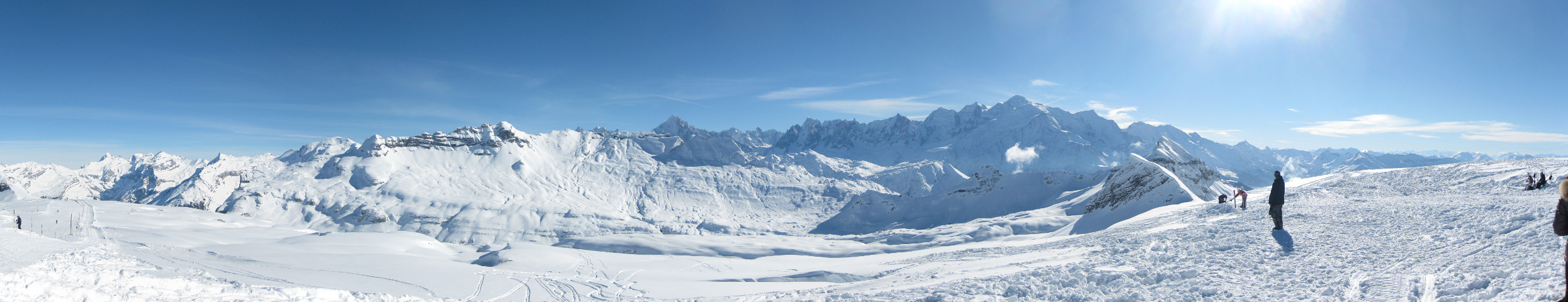
Afgelopen week was ik op vakantie in Flaine, gelegen in Le Grand Massif. Vanaf verschillende punten in het gebied heb je een mooi uitzicht op het Mont Blanc massif, en op een daarvan maakte ik het volgende panorama, bestaande uit 5 foto’s.
Beweeg de muis over de foto om door het panorama te scrollen.
Dit is het volledige panorama:

Klik erop om het plaatje in originele grootte (9050 x 1744 pixels) in een nieuw venster te bekijken. Het panorama is gemaakt met Hugin.


Up to now, I have been geotagging my pictures with gpsPhoto.pl, a command-line tool, that matches coordinates from GPX files with the timestamps on images. This works nicely, but it requires that you indeed have a GPX track from the time the picture was taken. For some time, I have been looking for a tool that allows me to do manual geotagging using a map.
I have found several tools that offer this functionality, or part of it. As a matter of fact, there are quite a few tools available for Windows, but I need one that runs on Linux, so I will not discuss those here. First, I found Geotag, a Java application, but it does not offer a map, so it isn’t very convenient. What I was looking for should look a lot like locr GPS Photo for Windows. This is, as the name suggests, a Windows-only tool.
Finally, I found GottenGeography, a GTK+ tool, written in Python, that does almost everything I want. Almost.
When I found GottenGeography, I had already started to explore the possibilities of writing a tool of my own, and the basis for Taggert was already there. After playing around with GottenGeography for a while, I decided I don’t like some of its design choices, and because creating a GTK+ application in Python seemed like a nice challenge, I decided to continue. And here it is: Taggert v1.0.

The README on Github explains what Taggert is, what it aims to be and how to try it out.
In short: Taggert allows add, change and remove geotags on your pictures, either manually using a marker on a map, or automatically using one of more GPX files containing GPS tracks. It allows you to store bookmarks for frequently-used locations and it supports multiple map sources, like OpenStreetMap and MapQuest.
In the near future, I hope to provide packages for different Linux distributions (at least Debian and Ubuntu). For now, you can download it from Github.